Exploring Deception Pass by Jack Hartt

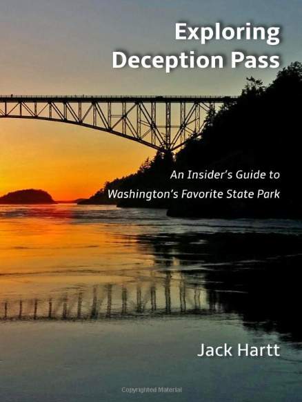
 This week, Jack Hartt’s new book Exploring Deception Pass was published. A recent Whidbey News Times Article by Ron Newberry on the subject (State park manager shares tales and insight) suggests, “When one of Washington’s most breathtaking state parks is part of your everyday life for 12 years, you tend to gain some unique insight.” Anyone who reads Hartt’s book will agree. Exploring Deception Pass is filled with dozens of (b&w) photos and includes information about: the history of Deception Pass and Deception Pass State Park (DPSP); the park’s flora and fauna; specifics about trails, hikes, happenings, things to do, and suggested visitor itineraries; its workers, both paid positions and volunteer; personal anecdotes from the park manager and maps. In summary, you’ll find everything you ever wanted to know about Deception Pass and Deception Pass State Park somewhere within the 224 pages of this informative, insightful book.
Plants of the Pacific Northwest Coast by Jim Pojar and Andy MacKinnon

 After checking out this book every spring for several years so that I could identify the beautiful wildflowers that bloom in abundance at Deception Pass State Park, I finally bought a copy. I’ve found it to be the most useful, entertaining guide for local wildflowers, trees, shrubs, grasses, mushrooms, lichen and mosses.
Seashore Life of the Northern Pacific Coast by Eugene N. Kozloff

 Once when I was completely stumped about a sea creature that I observed at Cornet Bay and Sharpe’s Cove at Rosario, I asked a UW marine biologist for help. He told me I’d found metridium senile, common name: plumose anemone, and recommended that I consult “Kozloff.” It’s a little textbook-y, but very helpful for both super savvy marine biologists and amateur sea life fans like me.
The Good Rain: Across Time and Terrain in the Pacific Northwest by Timothy Egan

 This 1991 collection of essays by Seattle native and New York Times journalist Timothy Egan is stuffed to the gills with facts about the wildlife, water and land in and around the Pacific Northwest. Each chapter begins with a map of the area under consideration, categorized by region and topic, including: a reclusive mountaineer’s conquests in the Cascade Range, local volcanoes, the wild waters around “We Ain’t Quaint” Astoria, the history of Seattle, apple harvesting in the Yakima Valley, the Native American Puyallups, and logging in the Siskiyous of southwestern Oregon. Although with a preachy style that would make Rachel Carlson proud, Egan is a fantastic storyteller with the ability to meld anecdotes, facts and opinion in such a way that every chapter is absolutely engaging.
Geology Underfoot in Western Washington by David Tucker

 After hiking Oyster Dome and the Rock Trail in Bellingham and thinking about kettles and the erratic in Coupeville, I tried to find out more information about the geological features at these locations, which led me to this book. Twenty two chapters cover as many areas and include: Buried in Ice-Repeatedly Whidbey Island and Honeycomb Weathering Larrabee State Park. Since finishing it, I’ve placed several of the geologic adventures on my Things to Do list.
Once They Were Hats by Frances Backman

 One of my obsessions during this past year was to observe a beaver in the wild, which I’d known exist in the Anacortes Forest Lands for years but had been unable to find. All that changed when I learned that DPSP is home to at least five of the skittish creatures. Earlier this year, I arrived several times at the Park with the sun (sometimes just as the rangers were unlocking its gates) in hopes of encountering a beaver. It worked! Author Frances Backhouse teaches creative nonfiction at the University of Victoria – and it shows. Her writing is as engaging and entertaining as it is informative. Each chapter in Once They Were Hats covers a unique topic about the largest rodent in North America.
Morris Graves Selected Letters by Vicki Halper and Lawrence Fong

 After first hearing about Morris Graves from a brochure about the Tursi Trail, I became obsessed with this famous artist who lived on the fringes of Deception Pass State Park in the early to mid 1940s. The book contains not only telling excerpts of correspondence to and from the artist, but also photographs of the man and his work. My favorite quote is from a 17 August 1942 letter, “We must—we MUST so live that we can sensitively search the phenomena of nature—from the lichen to the day moon—from the mist to the mountain—even from the molecule to the cosmos—and we must dream deeply down into the kelp beds and not let one fleck of the significance of beauty pass unappraised and unquestioned and unanswered—for here we (you and I and others) have a profound lead via beauty into the characteristic of God, and if we will live searchingly close to nature, we become aware of His ever-presence that is the awareness that heals the world—“ Wise words from a master Mystic.
Gathering Moss: A Natural and Cultural History of Mosses by Robin Wall Kimmerer

 Along with the basics about such things as what moss is, (p 13) “They lack flowers, fruits and seeds and have no roots. They have no vascular system, no xylem and phloem to conduct water internally,” and where they live (p 15) “Mosses inhabit surfaces: the surfaces of rocks, the bark of trees, the surface of a log, that small space where earth and atmosphere first make contact. This meeting ground between air and land is known as the boundary layer,” are stories, reflections and memories of these abundant (22,000 species) interesting (well…now they are) plants.
The Mushroom Hunters by Langston Cook

 Author Langdon Cook writes a lot about a guy named Doug Carnell, a quirky character (of course), who he spends time with in order to learn everything you ever wanted to know about harvesting wild mushrooms. Several others are also willing to show him the ropes, often involving picking without permits in areas where they are required and even on private land without the owner’s permission. The book covers such subjects as: mushroom hunting/hunters and collecting/collectors (chanterelles, porcini, black trumpets, boletes, truffles!), a mushroom competition, mushroom sellers/buyers, descriptions of mushroom-containing dishes, and David Arora (p 229), “…his book Mushrooms Demystified is largely responsible for introducing recent generations to the charms of mushroom hunting.”
101 Things to Do on Whidbey Island by Deb Crager

 Deb Crager has compiled an excellent, long list of things to do on Whidbey Island, many of which are free, categorized by season (Year-round events, Winter, Spring, Summer, Fall), which includes beach combing, bird-watching, cooking, dancing, ferry-riding, golfing, scuba-diving, horseback riding and much more. A list in the back of the book includes all 101 things, which allows adventurers to mark (or not) and make notes about their experiences. There’s also an alphabetical index and, best of the book, great color photographs, many taken by talented local photographers.
 1922 Deception Pass Land Becomes a State Park
 Multiples signs reading, “No Visitors,” “No Visitors Today,” greeted prospective callers to Morris Graves’ places of residence. Graves (1910-2001) was a tall, handsome, reclusive, prolific painter who bought 20 acres of land abutting the northwest corner of Deception Pass State Park on what is now called Rodger Bluff in 1939, lived and painted there for about five years between 1940 and 1947, moved away, and sold the property several years later.
 He explained the concept of the Inner Eye in an 18 Nov 1941 letter, [1]“I paint to evolve a changing language of symbols with which to remark upon the qualities of our mysterious capacities which direct us toward ultimate reality. I paint to rest from the phenomena of the external world—to pronounce it—and to make notations of its essence with which to verify the inner eye.” Duncan Phillips, founder of the Phillips Collection, wrote of him, [3]“Graves is a mystic touched with genius, one who paints for the “inner eye.” He haunts the mind and the senses like night sounds in a great stillness,” and, “Graves led a nocturnal existence at The Rock, tramping under a full moon until midnight, as we are told, then returning to paint until morning. You have the impression that each new discovery in paint is a night scene, and then the scene clears up as though the eye has been accustomed to this twilight and dawn world.”
 His series In the Night provides an example, [4]“I lived in a remote and extremely quiet part of the state of Washington. It was all stony hills, scrubby forests, and mountains that deflected every sound. You could hear the cattle, or a dog barking, from a great distance. The sound carried clearly, intensely. Living alone in that forest—kerosene lights, lamps after dark—you spent a lot of time outside, just listening and hearing what happened in the night—the forest creatures. That is the reason I painted this [In the Night], because I couldn’t identify certain sounds, and so any sound I could hear a paid attention to, and then quizzically and playfully tried to imagine what creature made the sound. I tried to paint a line of bird song. And there were some others sounds—surf that I tried to paint.”
 Birds were a primary subject at that time, often accompanied by ‘white writing,’ a technique he learned from artist Mark Tobey, then made his own. About Graves’ bird knowledge, Phillips noted, “He is familiar with that sardonic owl, that mighty eagle, that moon-crazed crow. His heart has gone out to the young plover fluttering in the shallow surf, and to the old gull, who with twisted plumage and shattered wings sinks at last into his world of boundless sea and sky gone black.”

 According to Skagit County Land Records, on 6 October 1938 graves bought the rectangular-shaped western parcel that included The Rock at a Skagit County land auction for $40, and 10 months later, bought a rotated L-shaped adjacent parcel (Lake View Addition to Fidalgo City) to the east on 8 July 1939, also for $40, about 20 acres altogether. In a letter he describes a visit to the site (12 October 1939), “Yesterday Mark [Tobey] and I spent on The Rock—poised on that great terrace halfway down the west side. There were great cobwebs of geese in the sky, great mantels of mist hovering [over] the hilltops, great streamers of mist caressing the face of the rock, moisture falling from the black fir trees. The grass is brown and silver and bent, and the moss turf lush and green…herons and mud-hens [American coot] rattled their rattling noises in the marsh under us, and red-tailed hawks wheeled and screamed and soared through the mists like super poetry written in space, out from the face of the wilderness.”
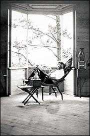 About a year later, in 1940, [5] “In the fall, Graves salvaged old lumber from abandoned homes and farms on north Whidbey Island to build a one room shed on the very top of The Rock,” and, two years later, [1]“Dorothy Miller, curator of painting and sculpture at the Museum of Modern Art, included Graves in her exhibition Americans 1942: 18 Artists from 9 States. This first New York show established Graves as a significant contemporary American artist. The museum acquired sixteen paintings from the exhibition. The director, Alfred Barr, purchased three additional paintings for himself. Graves used the money to complete the purchase of property on Fidalgo Island, Washington, where he built his first home, The Rock.”
 [5]“Graves is released from the military in March [1943] with an honorable discharge, which he verbally rejects. He returns to The Rock, but is disturbed by noise from the nearby military base on Whidbey Island; he paints Bird Maddened by the Sound of Machinery in the Air (1944) as a response to his frustration…Graves works on building a permanent house at The Rock, moving building materials alone by hand up the impassable driveway, and plants a garden. When he rests, he watches birds through field glasses.” William Valentiner, director of the Detroit Institute of Art describes The Rock (20 July 1943), “The place where he lives is indescribably beautiful. The house he built is perched on a rock like an eagle’s nest. It makes one dizzy to look down into the valley 1,000 [actually 400] feet below. The valley is covered with green trees, which, seen from above, appear like a green ocean. At each end of the valley is a lake [Pass], one with an island in the center [Campbell], and above the lakes rise other mountains, on one side in the far distance the Olympic Mountains, on the other, Mount Baker.”


 In 1952, Morris Graves sold the western 12ish acre parcel for $1,500. The real estate contract indicates a $600 down payment and monthly zero-interest payments of $50 until payoff. A year later, he, Mark Tobey, Guy Anderson and Ken Callahan were made more famous when the foursome were featured in the
  It’s been nearly 70 years since Graves left his life of solitude at the edge of DPSP. The cabin he built
 Morris Graves admonishes a friend, who could just as well be any of us, with this (17 August 1942), “We must—we MUST so live that we can sensitively search the phenomena of nature—from the lichen to the day moon—from the mist to the mountain—even from the molecule to the cosmos—and we must dream deeply down into the kelp beds and not let one fleck of the significance of beauty pass unappraised and unquestioned and unanswered—for here we (you and I and others) have a profound lead via beauty into the characteristic of God, and if we will live searchingly close to nature, we become aware of His ever-presence that is the awareness that heals the world—“
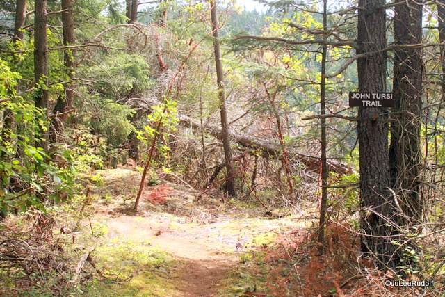

 A pair of butterflies (possibly Papilio rutulus) fluttered along beside me as I neared the Tursi Trail head along Donnell Road on Fidalgo Island a few weeks ago. As I began my hike along the dusty trail, a garter snake slithered off to safety. Thimble berries and trailing blackberries lined the primitive path during the first part of the climb. I was thinking about the amount of volunteer work that must’ve gone in to clearing brush when I came upon a very impressively built section lined entirely with jagged rocks.

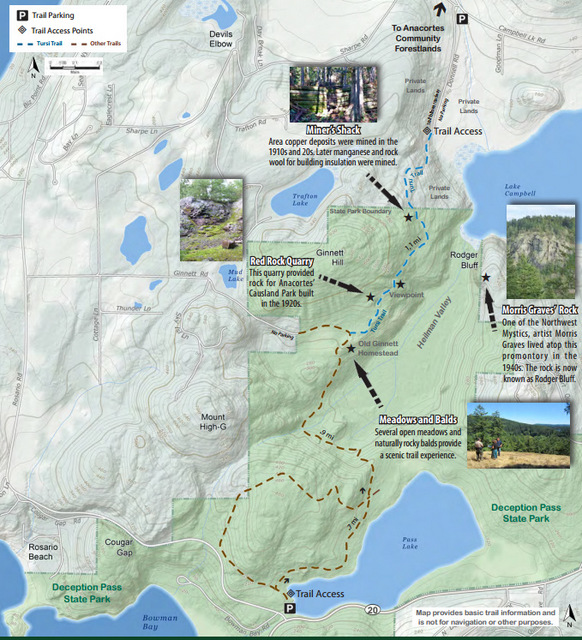


 First stop: just inside the Deception Pass State Park boundary, at the trail’s high point, I came upon a rock-lined cave (mine entrance) and the remains of Miner’s Shack. I’ve read David Quammen’s brilliant book about zoonoses, Spillover, in which bats play a prominent role in transmitting diseases between animals to humans, so I kept my distance from the cave, circled what remained of the shack, then checked out a mushroom growing out of a fallen moss-covered log.
 Second stop: an unobstructed view of Rodger Bluff, where mystic artist
  Further south, I observed mushrooms, mosses lichen, balds and beautiful views of Campbell Lake, as promised by a couple of guys I encountered in the pullout along Campbell Lake Road where I’d parked, about half a mile to the north of the trail head. Third Stop: Red Rock Quarry. Forget-me-nots and daisies grew along the trail near the jagged cliff face at the site of the former quarry. Minutes later, I noticed the John Tursi Trail sign, and knew I’d reached the Ginnett Trail and completed the connector between the Anacortes Forest Lands and Deception Pass State Park trail systems! After checking out the view of Campbell Lake from a large concrete pad, I retraced my steps, stopping to photograph Indian pipe. A turkey vulture soared overhead and cedar waxwings nibbled berries as I made my way back to the trail head along Donnell Road and then to my vehicle. Note: you may NOT park along Donnell Road.


 Afterwards, I decided to fulfill the Tursi Trail’s purpose as a connector between the Anacortes Forest Lands and Deception Pass State Park by running within both systems on the same day.
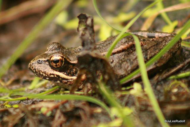
 Like the sirens to Odysseus, the frog chorus beckons me. From dusk to dawn I hear the call, pause, perk up my ears, wander towards the pond. Within a tiny plot of land, less than a tenth of an acre, an amphibian-friendly habitat exists where adults reproduce, eggs hatch, turn into tadpoles, finally form frogs. And the cycle begins again. Predators lurk and slither, hoping to make a meal out of a Pacific Tree frog. The sirens may not make the best comparison: at the end of my journey, a quick walk to just outside the limits of our fence, male frogs floating along the perimeter of the pond or near one of hundreds of cattails inflate their air sacs, then empty them with a bellow to attract females. Odysseus and his brethren faced a much more dangerous fate. As they hear my approach, they fall silent, but within minutes, my reassuring quiet allows them to begin again in a body of water that is simply a retention pond for a housing complex adjacent the Anacortes Forest Lands.


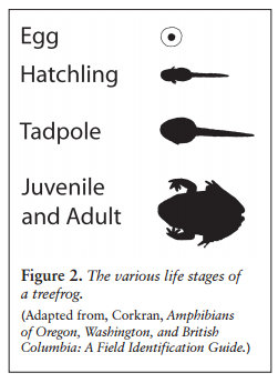


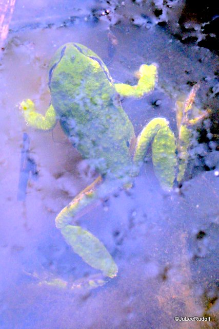


 Assumption: Piggyback frogs are adult/juvenile. Fact: “
 Assumption: Garter snakes eat only insects. Fact: “Garter snakes are known predators of Pacific treefrogs.” The first time I noticed Garter snakes near the pond, I knew they weren’t there just for the dragonflies, water striders and spiders. I felt fear for “my” frogs, especially when one of the largest ones I’ve ever seen slithered speedily between cattail stalks across the surface of the water. From
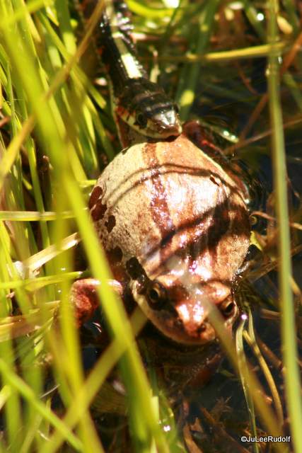
 Week in, week out, happenings in the drainage were my window into the world of pond creatures. One evening I was surprised to see what turned out to be a pair salamanders mating. My excitement changed to concern when I tracked the species down and learn that the pair were Sierra newts, listed as an invasive species at the WSDFW site.
 Per
Per  On a sunny afternoon in early April, I stumble upon a Painted turtle, the first I’ve seen on Fidalgo Island, nearly hidden in the shade of a small, grass-lined ditch that drains into the pond. According to
 Nearly three months have passed since the first time I strolled over to the pond. As the sounds have died down, so has my interest…until next year. I’ve been lucky enough not only to observe treefrogs in their natural habitat, but also newts, insects, spiders, birds, rabbits, deer, a turtle, and plenty of plants and wildflowers. Tiny, fascinating worlds are out there…sometimes right in our own backyard.
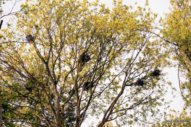
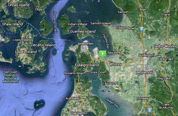
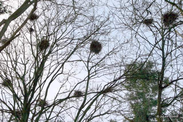
 In a small patch of March’s Point in Anacortes is a big secret: a heron rookery, also known as a heronry.
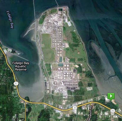 The southeast corner of March’s Point (see green box) is the home of the heronry, but most of March’s Point proper is the site of two refineries,
  SkagitBreaking.com
 Drive, bike or run the 7.4 mile road that follows the perimeter of March’s Point for great views of spectacular scenery: Mt Baker to the east, Guemes and the San Juan Islands to the north and Anacortes is to the west, and birds. In August, travel part of the distance on foot by running the

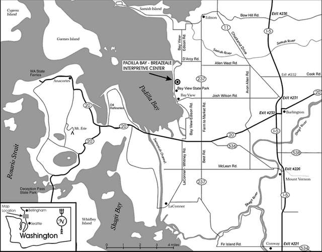
 I first learned of the existence of the heron rookery during a visit to the Padilla Bay Interpretive Center. A display provides information about the site and the


 During several trips this spring to the area of the rookery between March and May, bird activity increased significantly over time. If you brave a walk along the narrow shouldered road, pay attention to the sounds not only of the heron, but other birds like sparrows, towhees, eagles and hawks; check out the tadpoles transforming into frogs in the ditch; and enjoy the wildflowers, like Herb Robert and Nootka Rose. My advice: skip the camera, (the birds don’t come closer than about 100 feet from the ground, usually higher), take your binoculars and, most importantly, your quiet. Plan half an hour to walk and watch, then take a driving tour across the tracks and around March’s Point.


 It’s also why, when I noticed the paperback Once They Were Hats at
  Amidst my obsession, I came upon an article in the WNT,
 The following morning, I returned on a reconnaissance mission on a day with clear skies and temperatures in the forties–too late, I knew, to see the nocturnal creatures. At the specified (first) pullout, I spied: cormorants, Canada geese, mergansers and some sparrows. Near the first entrance to the campground, I found the beaver-felled-trees that had been removed to within a foot of the break point. At the last pullout before the parking lot, I noticed a family of raccoons, which I’d never seen before in the Park. Off towards Rosario Strait, gulls circled a crabbing boat as the crew pulled its pots with the snow-capped Olympics as a backdrop. Walking along the swimming area, lake water pressing underneath a layer of ice made sounds like cricket chirps.
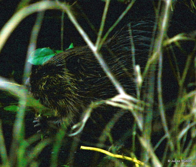
 Two days later, I arrived at 7:45 am, parked at the first pullout, cut my lights, rolled down my windows, and waited in silence. Hooded mergansers floated while eagles called. Reveille at NAS Whidbey marked the time as 8:00 am. Minutes later, my heart raced as I noticed what I’d hoped to see: a conspicuous V shape making its way towards me along the edge of the lake. As it neared, it submerged. When it hadn’t reappeared ten minutes later, I continued towards the West Beach parking lot. As I passed the road to the campground, I noticed a stout, wet rodent surveying the lake. It swam off, but a second and third beaver appeared. It was worth the wait of over a year when I finally encountered these brilliant builders. I returned to the bench where a beaver tail-slapped the water.

 On several subsequent trips, I arrived just after dawn, but before the sunlight had reached the lake and waited on the bench. A beaver broke through the ice and headed east. I hiked the short 0.3 mile distance between the dock and the bench.
 A sign indicated it was beaver territory, but it was unnecessary: felled logs lay in several spots. On a different trip, I met Ranger Rick as he unlocked the gate. He smiled, shook my hand and pointed to the beaver that was in the same spot it had been before – a stone’s throw from where we stood. I saw a second one, but he scared him off. He slipped into the water, sending bubbles to the surface.
 Along the trail to the dock, I flushed a heron, heard a Belted kingfisher’s call, and saw my second set of submerged beaver bubbles. Two swam nearby as Trumpeter swans situated towards the south honked. Yesterday, I made one last trip, knowing that my presence was affecting the beavers’ behavior. The rangers greeted me as I waited. I saw one near the gate. Half an hour later, it was time to go. As I walked back to my vehicle, I noticed what would have been the noisiest salad-making chef ever, ripping away at at thick leaves: a beaver was eating his way through one salal leaf after another. Before I said goodbye to the beavers of DPSP, I snapped one last photo.
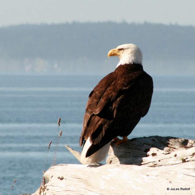


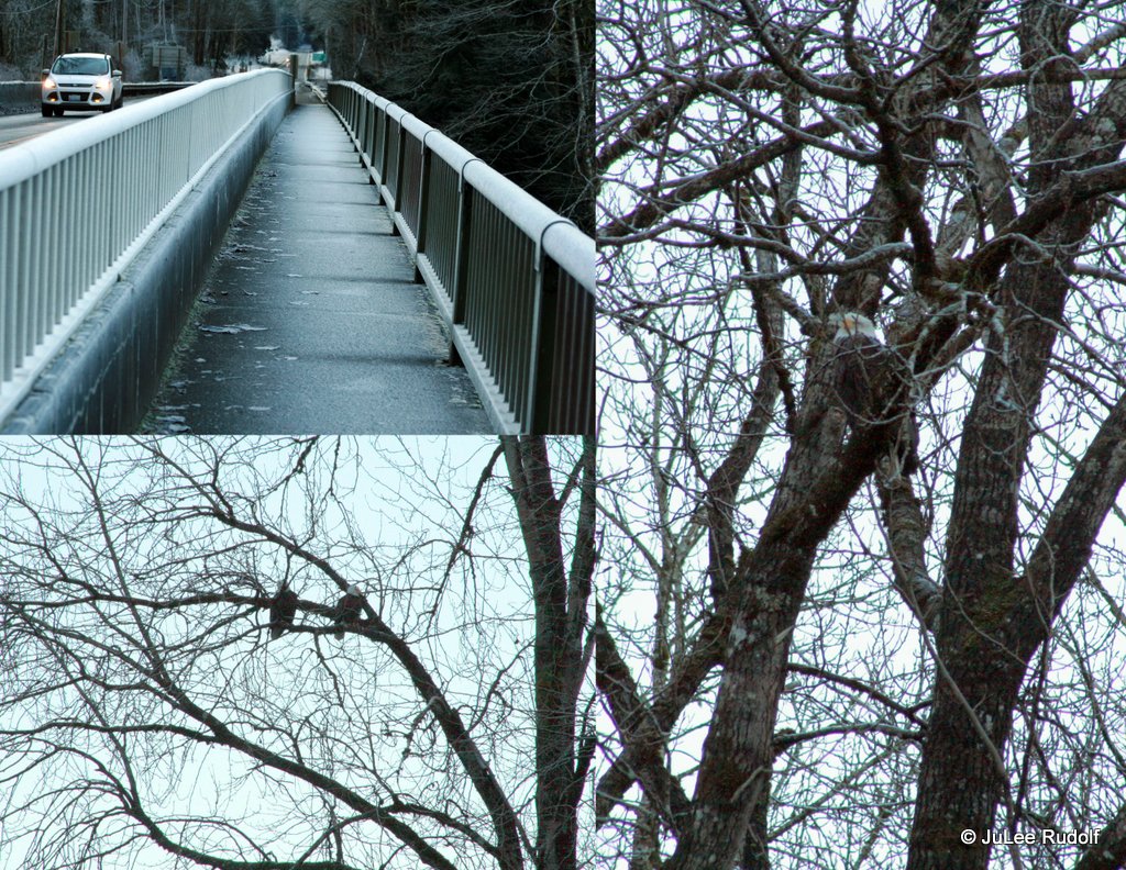
 During the ten years I lived on Whidbey Island, I encountered dozens of Bald eagles. In a typical week, I see several of these majestic birds, unmistakable as a bright white head atop a chocolate brown body. They tend to perch on wooden poles along Dike Road in Dugualla Bay, which is the area I photographed the adults in the collage. I observed the juvenile eagle from my living room window! Smaller birds seem to love to pester eagles, like the osprey in the bottom left photo. I’ve learned from observing them that, like people, each eagle looks a little bit different. One of my favorite eagle encounters was of an adult eviscerating a cormorant on the edge of Cranberry Lake in Deception Pass State Park in November of 2014.
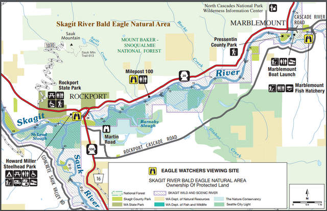 The
The 

 Second stop: Milepost 100, where the biggest surprise was the elderly guy walking along Highway 20 carrying a PEACE sign. One eagle flew high in the sky. A
 Last stop: the Marblemount Fish Hatchery. Two persons carrying cameras walked along the narrow road as we entered the grounds and arrived at a large parking lot next to the hatchery. A dozen gulls waited on the metal gratings over fish filled tanks hoping to get past netting that protected the fish. There wasn’t an eagle in sight…sigh, so we left.


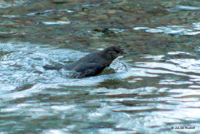
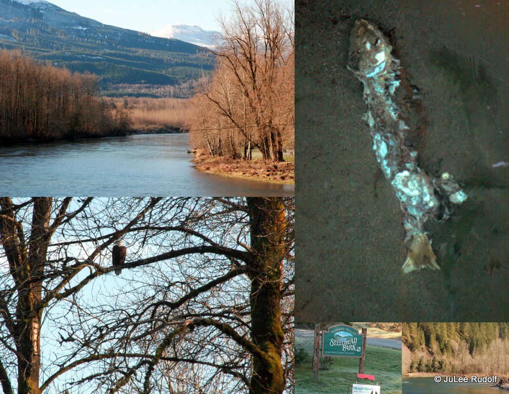
 I am not a quitter (plus, I love birds), so I awoke at 7:00 am on the first day of the year to try again during a cold, clear day. En route, I noticed half a dozen hawks perched in trees. Ten Trumpeter swans flew over near Burlington. Everything was covered with a thin crunchy layer of frost that looked like a dusting of snow. I sighted the first Bald eagle of the day at MP 78, another at MP 79 and a third at MP 90. I arrived at At Howard Miller Steelhead Park at about 9:00 am, an hour after sunrise, though the sun barely blanketed the tops of the nearby mountains with a gentle morning light. An eagle perched in a tree near the bridge-just like last time. A pair of eagles watched the river from nearby. Tour boats awaited a trip along the river. My return to MP 100 was disappointing. Again, one eagle. Again, the PEACE sign guy. At the Marblemount Fish Hatchery, I arrived as a white-bearded worker in winter gear shooed away the gulls that were hoping for a chance at the fish protected by netting. I greeted a couple of fisherman who planned to bait fish for Steelhead in the nearby Cascade River. I walked down a path towards Clark Creek and encountered a female Common merganser that appeared to be breast-stroke-like, siphoning the water through her beak. An inconspicuous small brown bird was submerging its entire body at intervals along creek but soon flew off. It was the first time I’d seen an American Dipper! Beyond the creek’s opposite shore, I could see five eagles, three adults, two juveniles, battling over what probably a fish carcass. An adult ate away while the others looked on. This was to be the best spot of the day. As I watched from afar, the hatchery worker encouraged me to move closer, so I did. Before I finally left because my fingers and toes felt frozen from the 25 degree temperature, I snapped one of my favorite shots of the day, of a sparrow on a grate above the hatchery.
 On the return trip, I stopped at a pullout to observe three eagles hunting from the same tree. A fellow eagle watcher showed me a few of the amazing shots he’d taken with his super extreme telephoto lens. Three other eagles were visible: two juveniles in a tree near the river and an adult on a small sand bar within the waterway. I watched and waited while others did same. In my second eagle observing venture, I’d seen: 3 along the highway between Sedro HMSP, 3 at HMSP, 1 at MP 100, 6 at the Fish Hatchery, 6 near HMSP and a bonus one as I reached Fidalgo Island, for a total of 20 eagles in one day…EAGLEMANIA. My advice: arrive as close to 8:00 a.m. (when the sun rises) as you can. Spend less time trying to photograph and more with binoculars. Unless you have a super mega telephoto lens with tripod, your eagles will likely look like tiny white specs. Dress for the weather. Be patient, but beware: eagle watching is addictive. I might just go back once more…
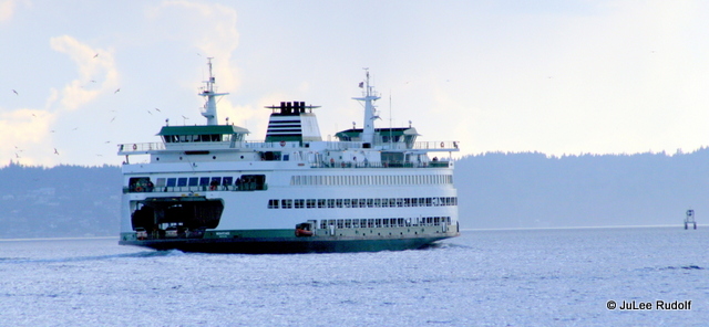


 More positives: no matter how short the trip, riders who make their way to the upper deck are bound to enjoy the experience. Seeing these juvenile gulls one mid-July day as we departed the Coupeville terminal was one of my favorite ferry-travel wildlife encounters of all time.
 The
The 
 Including Capital Costs into the ratio ($303.3 million)-and why aren’t Capital costs included in the standard of comparison-for the WSF system-the ratio of Ferry Fare collection/Capital plus Operating cost is 0.46, which is better than the RRR for every mode of transit except Vanpool.

 A WSDOT publication from January of 2011, “Comparison of Ferry Employee Benefits and Work Rules to General State Government Worker Benefits,” concluded that, “Annual costs for ferry workers in comparison to general state government employees, assuming the same hours worked, same rate of sick leave use, and equivalent length of employment for purposes of calculating vacation accruals, is approximately $6.5 million.” That fact seems to contradict Ed Friedrich’s April 2012 Kitsap Sun article,
 In conclusion, the WSF system is not without waste. Costs associated with Ferry employee benefits and work rules compared to those of general state government workers are significant, as are Capital costs associated with terminal maintenance and ferry fleet maintenance and replacement; however, the metric by which the efficiency of public transportation systems are measured and compared, the Revenue Recovery Rate, for WSF is about 75%, at least three times as efficient as all other modes of public transit except Vanpooling. Based on that fact and a non-data-driven analysis, my own experiences during dozens of trips on ferries, I’ve found WSF workers to be both friendly, patient and efficient, which leads me to believe that the WSF system succeeds at their mission, “to make a positive contribution to the livability and economic vitality of our region by providing a safe, reliable, and efficient ferry transportation system.” For more information about the
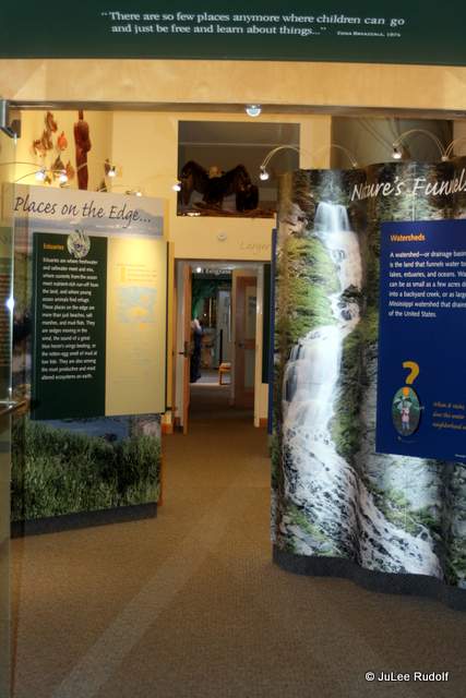
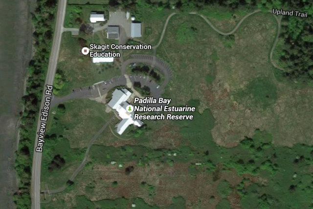
 Admission is free, but they request donations, so I placed mine in a clear plastic cube and walked past a perimeter wall displaying the story of the Breazeale family’s involvement in the project. They donated the 64 acres on which the interpretive center, built in 1982, stands. Continuing on, I entered a long, high ceilinged room with colorful displays about the estuary and the area’s flora and fauna. Things had changed little, if at all, since the last time I visited during an elementary school field trip seven years prior. I pressed a button to hear taped eagle’d call. It sounded like it’d caught a cold. One display included sand fleas…with legs made of springs.
  Stationary fish species gazed down from above. The area was clean, neat and informative, but outdated. After reading about the estuary, eel grass, and a nearby heron rookery (Up in the Trees with Great Blue Herons), I made my way to the next section, about the sea.


 Several tanks filled with creatures had been my favorite part of the interpretive center the first time I visited, and were again. Fish swam, shrimp crawled. A sea star, Peach-from-Finding Nemo-style, disengaged an arm from the rocks. Was it beckoning me? Under a curved tank arch, a sign asked visitors to forgive the rubber stuff. What? Fake things in tanks? The rubber version of a Painted anemone didn’t do justice to the ones I’d seen in situ at Deception Pass State Park though a real live Plumrose anemone did. Stuffed birds showed the comparative sizes of owl, eagle, hawk.
 Sunlight streamed through the window of the Hands-On Room which I entered next. A mural with removable felt birds and fish beckoned. Games, puzzles and puppets provided ways to learn while playing. Here I noticed the second of only two employees during my visit: a man who greeted me from a room at the back and answered my questions about beavers, which I’ve tried but failed to find in the ACFLs. He pointed out a beaver skull as we commiserated about their elusiveness. He directed me to the trail and offered binoculars, which I declined.
 I popped my head into the library, available for public use, then headed to the nearest exit. First I walked towards the road, through a small tunnel and tried to reach the beach, but the tide was so high that I would have hit water at the bottom, so I skipped the steep intimidating spiral staircase and walked up the hill towards the trail head instead.


 The 0.8 mile long nature trail lies above the center. Wheelchair access ends early, but the rest is easily accessible to the ambulatory. The path is lollipop-shaped with the stick part at the start. I followed the paved to graveled to woodsy to grassy path through some trees to a huge neighboring pasture filled with unusually furry grazing cattle. Near the end of the loop, a sign warned of bees in the trees, but I didn’t see them as I made my way past. I enjoyed my visit to the Padilla Bay Estuarine Research Reserve including the Upland Trail, which I completed in about an hour. But then, I was the only one there.

 I returned a week later and stopped at the west side of Bay View State Park south of the interpretive center, passed by the camping area, crossed under the road, and parked in the lot. Towards the west is a fenced, grassy area with an enclosed-on-three-sides covered picnic area, restrooms, about 20 picnic tables and an information kiosk. An 8.5×11 sheet showed local bird species, but the only live creature I saw, my nemesis bird (the Belted flycatcher), was not shown. At high tide, little of the beach was exposed. To the south it was rocky, while the west and north were sandy enough to build sand castles in warmer weather.


 Bay View State Park is not only a great place for a picnic, but was also the location of the start for the
